This product supports Nanite for Unreal Engine 5.0+
Features:
-
1 x level with spherical planet and atmosphere to real-world scale with tiled country meshes [New]
-
1 x level with spherical planet and atmosphere to real-world scale with tile meshes [Deprecated – to be removed from the project in a future update – superseded by tiled country meshes]
-
1 x level with georeferenced oblate spheroid planet and partially overlapping atmosphere to real-world scale with tile meshes [Deprecated – to be replaced by tiled country meshes version in a future release].
Number of Unique Meshes: 981
Collision: (Yes – automatically generated)
Vertex Count: ~42,000,000
LODs: (No)
Number of Materials and Material Instances: 7 Materials, 825 Material Instances
Number of Textures: 405
Texture Resolutions:
-
8192×8192
-
8192×7160
-
4096×4096
Supported Development Platforms:
Windows: Yes
Documentation:
Documentation will be added in a future release. Until then, please see the Demo Video
If you are experiencing Nanite triangulation issues or Memory Pool size issues, please press play and stop to execute the console variables in the Level Blueprint.
Notes:
This project uses data from NASA sources. Many thanks to NASA for their incredible work, especially the team behind Visible Earth.
本产品支持Nanite for Unreal Engine5.0+
特征:
-
1x水平与球形行星和大气到现实世界的规模与平铺的国家网格[新]
-
1x水平与球形行星和大气与现实世界规模与瓷砖网格[弃用-将在未来的更新中从项目中删除-由瓷砖国家网格取代]
-
1x级与地理配准的扁圆球行星和部分重叠的大气与现实世界的比例与瓷砖网格[弃用-将取代瓷砖国家网格版本在未来的版本]。
唯一网格数:981
碰撞:(是-自动生成)
顶点数:~42,000,000
Lod:(不)
材质和材质实例数:7个材质,825个材质实例
纹理数量:405
纹理分辨率:
-
8192×8192
-
8192×7160的
-
4096×4096的
支持的开发平台:
Windows:是的
文件:
文档将在未来的版本中添加。 在那之前,请参阅 演示视频
如果您遇到Nanite三角测量问题或内存池大小问题,请按播放和停止以执行关卡蓝图中的控制台变量。
注意事项:
该项目使用NASA来源的数据。 非常感谢NASA的令人难以置信的工作,特别是Visible Earth背后的团队。

Ultimate Earth
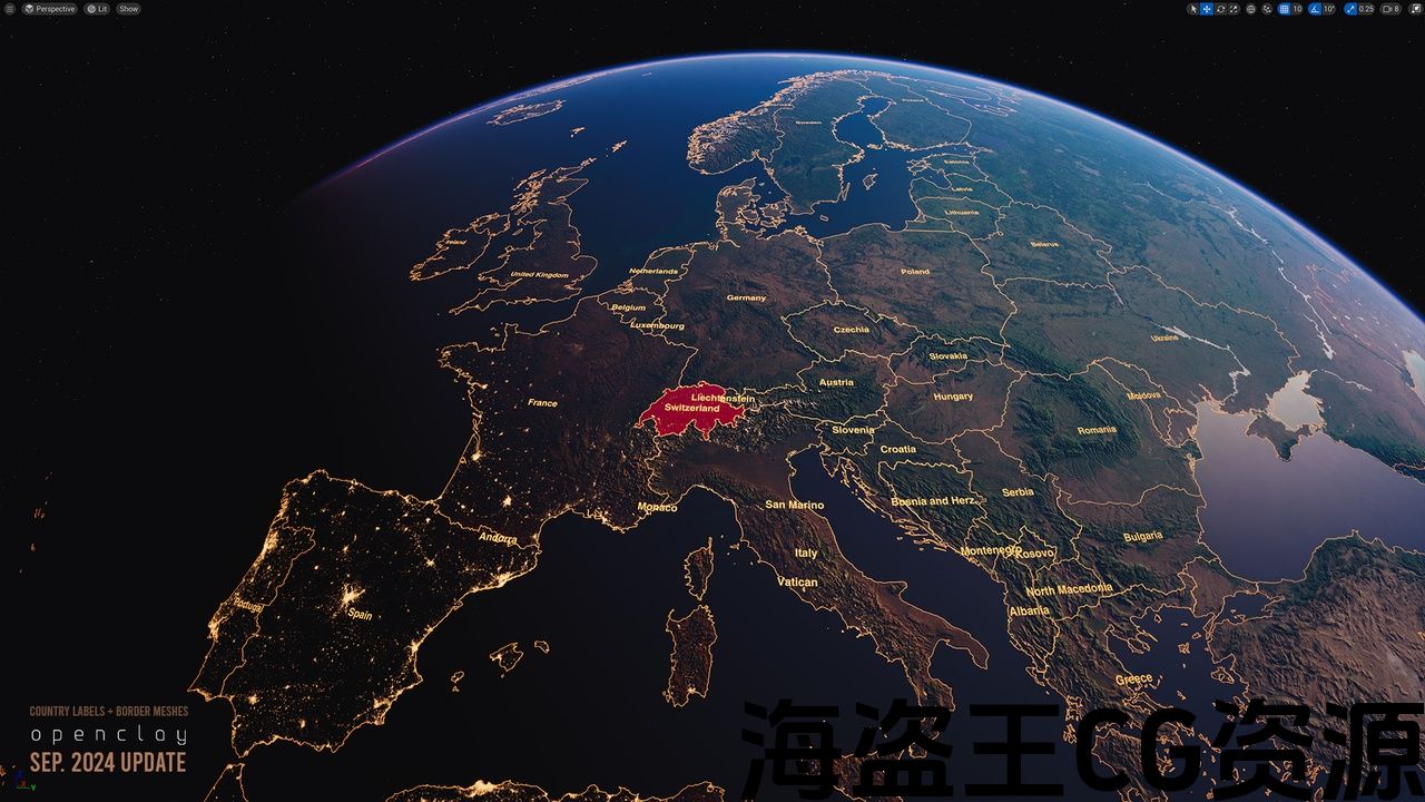
🎉UPDATE 2024-09-18: Country labels and border meshes added!
🎉UPDATE 2024-02-26: Country meshes and materials added – more details below! See the features here!
Historical Questions and Reviews (pre-FAB). Have more questions? Please feel free to ask questions in our Discord.
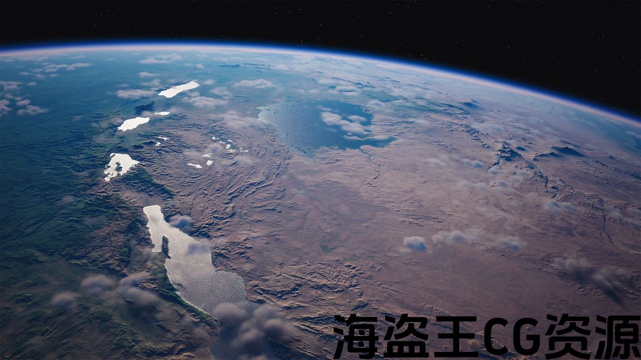
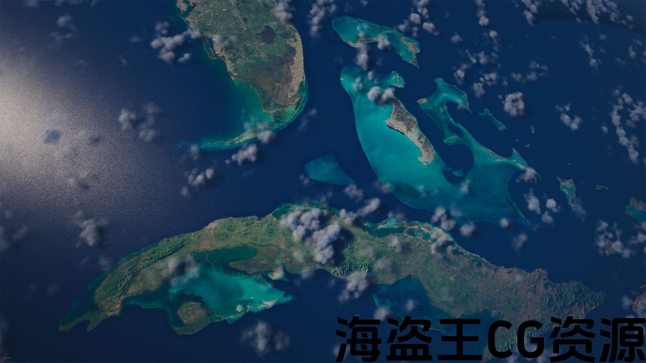
Ultimate Earth (formerly Giga Earth) is derived from over 2 billion polygons, with the optimised terrain data powered by Nanite, enabling cinematic viewing of Earth for games, cinematics and interactives, in real-time. This Earth is built to scale and leverages Epic’s atmosphere to dynamically light and shade the atmosphere depending on the angle it’s set to.
If you like it, please leave a review! It motivates us to improve the project. If you have suggestions for improvements please ask a question or let us know. Thank you!
Surface
The color map comprises 81,920 pixels wide and 40,960 pixels high and has been hand painted to have many data processing artefacts removed. The normal map comprises 81,920 pixels wide and 40,960 pixels, and allows for normal flatness to be adjusted, changing the intensity of the terrain features to better suit the different artistic needs of near and far shots.
Night Lights [texture]
-
Visibility driven by lack of sunlight
-
Adjustable Intensity
-
Adjustable Color
-
81k of texture
Clouds – Volumetric (for close shots [experimental])
-
Simple volumetric clouds (as shown in stills [requires ‘Volumetrics’ plugin be turned on])
Clouds – Textured (for medium to long shots)
-
Adjustable normal flatness
-
41k of pixels of real cloud texture
Country Borders [texture]
-
Adjustable Intensity
-
Adjustable Color
-
81k of texture
Stars [texture]
-
Adjustable Brightness
-
8192×8192 pixel texture map
Watch – Demo Video
Discord – Openclay Creator Discord
Hardware
Nanite on PC requires the following;
-
NVIDIA: Maxwell-generation cards or newer
-
AMD: GCN-generation cards or newer
Notes:
This project is ~10.7 GB in size.
This project requires the ‘Volumetrics’ plugin be activated to use the volumetric clouds.
Volumetric clouds have limited range of shadows (~400km) – see gallery for examples. Volumetric clouds will cause shadow streaking beyond this if viewed from far out distances.
If you are looking to render out movie sequences, a graphics card with 16GB+ of dedicated VRAM is recommended – ideally 24GB+. If you are using UE 5.1 or great with DX12 and experiencing crashes, please use the following video to help render out sequences after UE 5 with DX 11:
Ultimate Earth requires SM6 to be enabled for Nanite if using Unreal Engine 5.1+. SM6 is enabled by default in Unreal Engine 5.1+.
-
This project does not include heightmaps.
-
Please press play and then stop in the editor to execute the recommended console variables.
-
Ultimate Earth requires SM6 to be enabled for Nanite if using Unreal Engine 5.1+. SM6 is enabled by default in Unreal Engine 5.1+.
-
Please see the Nanite documentation below for more information
https://docs.unrealengine.com/5.0/en-US/nanite-virtualized-geometry-in-unreal-engine/
If large seems are still present, navigate to your Unreal Engine Project Folder, and locate DefaultEngine.ini. In a text editor, such as Notepad or Notepad ++, edit this file. Change the following
from
[/Script/WindowsTargetPlatform.WindowsTargetSettings]
DefaultGraphicsRHI=DefaultGraphicsRHI_Default
to
[/Script/WindowsTargetPlatform.WindowsTargetSettings]
DefaultGraphicsRHI=DefaultGraphicsRHI_DX12
Questions
If you have question, please ask and we’ll see how we can help.
Email – epicsupport@openclay.com
Version Log (in future logs will be condensed to a linked document):
v 1.1.0 Changes (released 18th September, 2024)
-
Added country labels as static meshes.
-
Added country border static meshes.
v 1.0.0 Changes (released 26th February, 2024)
-
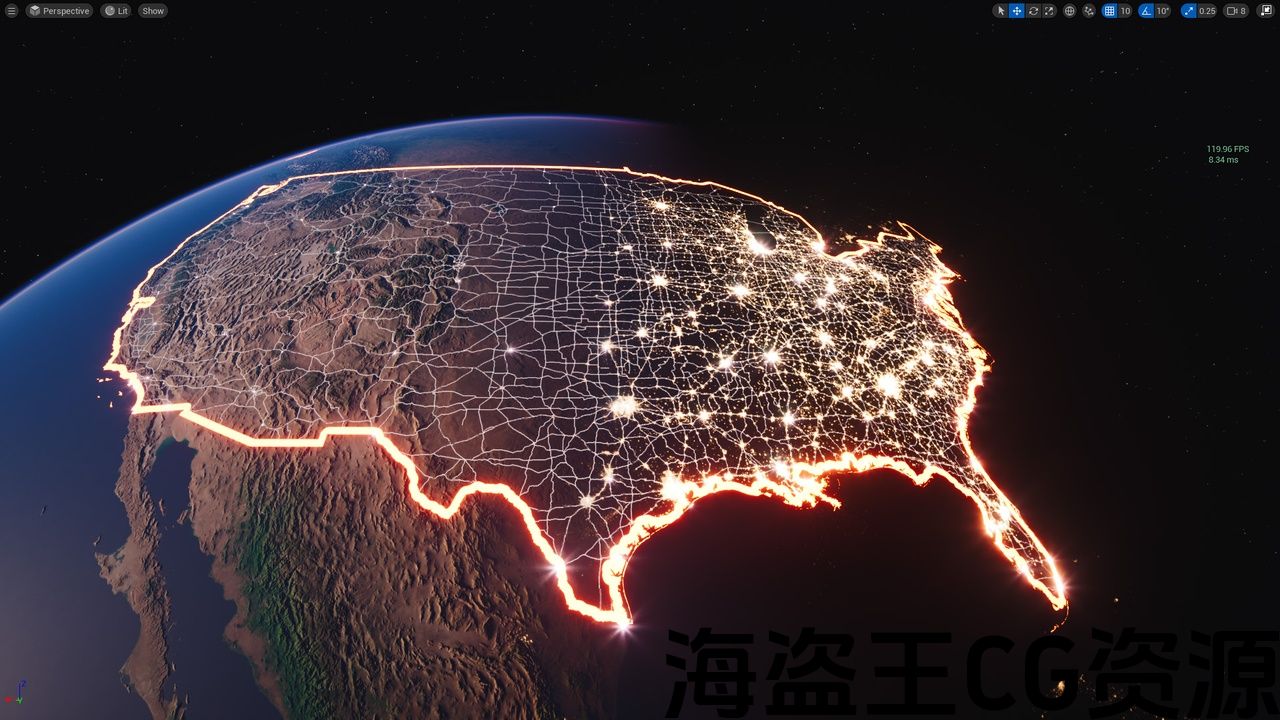
Added countries level – containing country meshes and materials. Each country has a material to control all the material parameters for it, allowing fill, borders, roads etc to be controlled on a per-country basis.
-
Added twinkling stars.
-
Added parameter controls for border thickness, surface lights advancement/retardation and surface lights terminator sharpness.
-
Added pulsing country fill material parameters – intensity, color, speed and timing offset:
-
Added country fill emission intensity and color material parameters.
-
Switched shadows to Virtual Shadow Maps
-
Increased last clip map level of Virtual Shadow Map for better distant shadows (press play in the Editor to execute).
-
Set the streaming pool size to 5 GB (press play in the editor to execute).
-
Removed 100 + graphical artefacts in the ocean, so the water largely has sharp black/blue band transitions removed.
-
Removed North/South aligned specular artifact between tiles 35 and 36
v 0.9.0 Changes (released 16th September, 2023)
-
Added georeferenced level – requires Georeferencing plugin to be activated. Additionally the atmosphere does not cover this planet version fully, as the Earth is an oblate spheroid in this level while the atmosphere remains spherical. Lat and long usable, altitude not at this time.
-
Added major roads, railways, ports and airports of the world as textures.
-
Added parameter controls for color and intensity of roads, railways, ports and airports.
-
Reorganised material parameter names and created groups for easier use.
-
Fixed grey halo on water/land boundaries.
-
Fixed flickering cloud issue in UE 5.3 (press play in editor to execute console variable)
v 0.8.0 Changes (released 28th April, 2023)
-
Country borders texture added
v 0.7.0 Changes (released 24th March, 2023)
-
Earth Surface master instance material now controls surface parameters.
-
Land tint color and strength
-
Water tint color and strength
-
200 + artefacts removed from cloud textures
-
Cloud texture now wraps with seamless texture
-
Cloud texture shadow geo added (not for volumetric clouds) [experimental]
-
Cloud texture geo now has shadows off
-
Added control groups to turn cloud geo and cloud geo shadow on and off more easily
-
Cloud tile 2 texture corrected
-
Fixed cloud texture maps border between 21 and 30
-
r.Nanite.MaxPixelsPerEdge 0.05 added to Level Blueprint (press play to execute)
-
Surface roughness default increased to 0.5
-
Star brightness default increased to 5
v 0.6.0 Changes (released 28th February, 2023)
-
Added volumetric clouds
-
Added animated waves (normal map) on water bodies
-
Refined specular/roughness reflection on water bodies
-
Adjusted post processing volume grading
v 0.5.3 [released 17th February, 2023]
-
Ultimate Earth released!
终极地球
📷展览短片
🎉更新2024-09-18:国家标签和边界网格添加!
🎉更新2024-02-26:国家网格和材料添加-更多细节如下! 查看功能 这里!
历史问题和评论(PRE-FAB)。 还有问题吗? 请随时在 我们的不和.
终极地球 (以前的Giga Earth)来自超过20亿个多边形,通过Nanite提供的优化地形数据,可以实时观看游戏、电影和互动的地球电影。 这个地球是建立规模和利用史诗的大气动态照明和阴影的气氛取决于它的角度设置。
如果你喜欢它,请留下评论! 它激励我们改进项目。 如果您有改进建议,请提出问题或 让我们知道. 谢谢!
表面
彩色地图包括81,920像素宽和40,960像素高,并已被手绘以移除许多数据处理文物。 法线贴图包括81,920像素宽和40,960像素,并允许调整法线平坦度,改变地形特征的强度,以更好地适应远近拍摄的不同艺术需求。
夜灯[纹理]
-
缺乏阳光驱动的能见度
-
可调节强度
-
可调颜色
-
81k的纹理
云-体积(用于近距离拍摄[实验])
-
简单的体积云(如剧照所示[requires’Volumetrics’plugin be turned])
云-纹理(适用于中长镜头)
-
可调节正常平面度
-
41k像素的真实云纹理
国家边界[纹理]
-
可调节强度
-
可调颜色
-
81k的纹理
星星[纹理]
-
可调亮度
-
8192×8192像素纹理图
手表 – 演示视频
不和谐 – 开放式造物主不和谐
硬件
Pc上的Nanite需要以下内容;
-
NVIDIA:Maxwell-generation卡或更新
-
AMD:GCN代卡或更新
注意事项:
这个项目是~10.7GB的大小。
该项目需要激活”Volumetrics”插件才能使用体积云。
体积云的阴影范围有限(约400公里)-请参阅图库的例子。 如果从远处观察,体积云将导致阴影条纹超出此范围。
如果您希望渲染电影序列,建议使用具有16gb+专用VRAM的图形卡-最好是24gb+。 如果您在DX12上使用UE5.1或great,并且遇到崩溃,请使用以下视频来帮助在DX11上使用UE5后渲染序列:
如果使用虚幻引擎5.1+,终极地球需要为Nanite启用SM6。 默认情况下,在虚幻引擎5.1+中启用SM6。
-
此项目不包括高度图。
-
请按播放,然后在编辑器中停止以执行推荐的控制台变量。
-
如果使用虚幻引擎5.1+,终极地球需要为Nanite启用SM6。 默认情况下,在虚幻引擎5.1+中启用SM6。
-
有关更多信息,请参阅下面的Nanite文档
https://docs.unrealengine.com/5.0/en-US/nanite-virtualized-geometry-in-unreal-engine/
如果仍然存在大型项目,请导航到虚幻引擎项目文件夹,并找到DefaultEngine。ini。 在文本编辑器(如Notepad或Notepad++)中,编辑此文件。 更改以下内容
从
[/Script/WindowsTargetPlatform。WindowsTargetSettings]
DefaultGraphicsRHI=[医]DefaultGraphicsRHI_Default
到
[/Script/WindowsTargetPlatform。WindowsTargetSettings]
DefaultGraphicsRHI=DefaultGraphicsRHI_DX12
问题:
如果你有问题,请问,我们会看到我们能提供什么帮助。
电邮-epicsupport@openclay.com
版本日志(在未来的日志将被浓缩到一个链接的文档):
v1.1.0更改(2024年9月18日发布)
-
添加国家标签作为静态网格.
-
新增国家边界静态网格体。
v1.0.0更改(2024年2月26日发布)
-
添加了包含国家级别的国家网格和材料。 每个国家都有一个材料来控制它的所有材料参数,允许填充,边界,道路等在每个国家的基础上控制。
-
增加了闪烁的星星。
-
增加了边框厚度,表面光源前进/延迟和表面光源终结器清晰度的参数控制。
-
增加脉冲国家填充材料参数-强度,颜色,速度和时间偏移:
-
添加了国家填充发射强度和颜色材料参数。
-
将阴影切换到虚拟阴影贴图
-
增加虚拟阴影地图的最后剪辑地图级别,以获得更好的远处阴影(在编辑器中按播放执行)。
-
将流池大小设置为5GB(在编辑器中按play执行)。
-
去除了海洋中的100多个图形文物,因此水中大部分都去除了尖锐的黑/蓝带过渡。
-
移除瓷砖35和36之间的北/南对齐镜面伪影
v0.9.0更改(2023年9月16日发布)
-
添加地理参考级别–需要激活地理参考插件。 此外,大气并没有完全复盖这个行星版本,因为地球在这个级别是一个扁圆球,而大气仍然是球形的。 Lat和长时间可用,高度不是在这个时候。
-
增加了世界主要公路,铁路,港口和机场作为纹理。
-
增加了道路,铁路,港口和机场的颜色和强度的参数控制。
-
重新组织材料参数名称和创建的组,以便于使用。
-
固定水/陆地边界上的灰色光环。
-
修正UE5.3中的闪烁云问题(在编辑器中按播放以执行控制台变量)
v0.8.0更改(2023年4月28日发布)
-
添加了国家边界纹理
v0.7.0更改(2023年3月24日发布)
-
地球表面主实例材质现在控制表面参数。
-
土地色调的颜色和强度
-
水的颜色和强度
-
从云纹理中移除200多个人工制品
-
云纹理现在包裹无缝纹理
-
添加云纹理阴影(不适用于体积云)[实验]
-
云纹理地理现在有阴影关闭
-
添加控制组,以更轻松地打开和关闭云地理和云地理阴影
-
云瓦2纹理修正
-
固定云纹理地图21和30之间的边界
-
纳米石。MaxPixelsPerEdge0.05添加到关卡蓝图(按播放执行)
-
表面粗糙度默认增加到0.5
-
星星亮度默认值增加到5
v0.6.0更改(2023年2月28日发布)
-
增加体积云
-
在水体上添加动画波浪(法线贴图)
-
水体上精细的镜面/粗糙度反射
-
调整后处理量分级
v0.5.3[2023年2月17日发布]
-
终极地球释放!
评论(0)